Well I am now without Microsoft Office plus a short PS
I have Office back (?). By various manipulations I have my cursor back and control of Mouse.
I have been looking at Vaalbara supercontinent fragments Kaapvaal and Pilbara. I am now SERIOUSLY convinced that if Vaalbara was fully reconstituted (sounds like food stuff, eh) we would have the River Pison. Without revealing a source - this might seem weird but the writer was anathematised many years ago and the source might trip up 'little ones' - I have come to see that four rivers ran together INTO the Garden and out as one river. This is mind-bending stuff, just take it for what it is worth. So the River Pison could have done McCarthy and Rubidge's braiding scenario and joined to meander for a lot to join then other three.
It would be interesting to see the whole of Vaalbara and Eden (which is itself apparently a big, BIG piece of territory) as it was.
There is some good material here Eden .
.
Read the following quote;
I wonder if this part of Greenland was another portion of Vaalbara. Was this river Frath or one of the other two? Barry has "...
Besides its unusual geology, the Afar region is famous for its fossils. On November 24, 1974, a team of American paleoanthropologists led by Donald Johanson discovered a fossil hominid of a young adult female only a meter tall. While the team examined the find, the Beatles song Lucy in the Sky with Diamonds played on the radio, and the team decided unanimously to call the fossil “Lucy.” Years later, she got her formal scientific designation: Australopithecus afarensis. Radiometric dating of underlying volcanic rocks placed Lucy’s age at 3.2 million years old.
From: NASANews@hq.nasa.gov
SPACE RADAR UNEARTHS SECRETS OF THE ANCIENT NILE
One of the many great mysteries of the Nile river may be solved with the discovery of an ancient river channel buried under layers of sand in the Sahara Desert in Africa.
The buried river channel was revealed in images taken by the Spaceborne Imaging Radar C/X-Band Synthetic Aperture Radar (SIR-C/X-SAR) that flew twice on the Space Shuttle Endeavour in 1994. The radar images were processed at NASA's Jet Propulsion Laboratory (JPL), Pasadena, CA, and the University of Texas at Dallas (UTD).
A scientific paper on the discovery written by Stern and co-authored with UTD geologist Dr. Mohamed Gamal Abdelsalam appears in the Dec. 6 issue of Science magazine. The discovery grew out of research that the scientists have been doing on plate tectonics and the formation of a "supercontinent" more than 600 million years ago.
---end---
PS Compare the DD of -4252 with Enos' rule according to Dave Fasold and Berossus and the titling below
I have been looking at Vaalbara supercontinent fragments Kaapvaal and Pilbara. I am now SERIOUSLY convinced that if Vaalbara was fully reconstituted (sounds like food stuff, eh) we would have the River Pison. Without revealing a source - this might seem weird but the writer was anathematised many years ago and the source might trip up 'little ones' - I have come to see that four rivers ran together INTO the Garden and out as one river. This is mind-bending stuff, just take it for what it is worth. So the River Pison could have done McCarthy and Rubidge's braiding scenario and joined to meander for a lot to join then other three.
It would be interesting to see the whole of Vaalbara and Eden (which is itself apparently a big, BIG piece of territory) as it was.
There is some good material here Eden
.Thus, let's try to put the words in as they were written, or at least the meanings:Further to Barry's above quote he elaborates at www.setterfield.org. This leads us to the area where the Sethites lived for Hiddekel - my guess Siberia or Tarim, as there, there are very early slivers of the pre-Cambrian.
"A river watering the garden flowed from Eden; from there it was separated into four headwaters. The name of the first is the Pishon (or that which spreads out); it winds through the entire land of Havilah (the twisting land), where there is gold. (The gold of that land is good; aromatic resin and onyx are also there.) The name of the second river is the Gihon (the Stream); it winds through the entire land of Cush. The name of the third river is the Hiddekel (it flows very rapidly); it runs along the east side of Asshur (or it runs straight-forwardly to the east.) . The fourth river is the Perath (the one that breaks forth.)"
Read the following quote;
News & Blogs
By: By Terrell JohnsonGreenland's 'Grand Canyon' Found Under Ice Sheet
Published: August 30, 2013 Hidden under more than a mile of ice for millions of years, a massive mega-canyon
"One might assume that the landscape of the Earth has been fully explored and mapped," Jonathan Bamber
Using data collected over the past few decades by NASA and researchers from Germany and the U.K. with ice-penetrating radar equipment hung from the belly of an airplane
The canyon begins near the center of Greenland and continues all the way to the Petermann Glacier fjord, which empties out on the northern coast. This suggests that the canyon was carved by an ancient river
J. Bamber/University of BristolA 3-D image of the canyon under Greenland's ice sheet.
"Nowhere does it look like a typical U-shaped valley," Bamber told NPR in an interview yesterday, noting that's the shape a glacier-carved canyon
Because the canyon slopes continuously and gradually on its meandering path toward the sea -- without the ice sheet sitting on top of it, a river in the canyon would drop nearly two feet every mile, the scientists estimate
"We think this was a major river system in Greenland before the ice sheet was there," he says. "And it's just survived the cover by the ice sheet."
This helps explain why Greenland doesn't have large sub-glacial lakes under its ice, unlike Antarctica, the scientists say -- because the canyon transports meltwater from Greenland's interior
The researchers in the study pieced together data from radar images of the ice taken over the past 40 years, much of collected by missions like NASA's Operation IceBridge
From the images they collected, the scientists assembled a three-dimensional map of the landscape underneath Greenland's ice sheet. It was only then that the canyon came fully into view, Bamber said in an interview with the London Telegraph
“It is a huge feature and it was quite a surprise to all of us that it was really there," he told the U.K.-based newspaper. “We are pretty excited and amazed when we discovered this huge, undiscovered feature.”
I wonder if this part of Greenland was another portion of Vaalbara. Was this river Frath or one of the other two? Barry has "...
it would be surprising if the location of the present day river Euphrates had any relationship to the original river familiar to Adam."
Slave craton

(The Slave Province is "A" in the image at left - magnify
(more images at Geomorphology, lithology, geological history of the Slave craton
Rock formations of the Slave Craton comprise ancient crust including the Acasta Gneiss Complex
The Slave craton is a mere fragment of ancient crust, surrounded by Paleoproterozoic
large late Archean supercontinent
_____________________________↓
late Archean parental supercraton Sclavia → Slave _ + Rae (~2 Ga) → Laurentia
__________________________________________________________+
_________________________________________Baltica
_____________________________________________ and possibly Siberia
________________________________________________↓
______________________Columbia (Nuna, Hudsonland, Hudsonia) 1.8-1.5 Ga
The original landmass could have been the speculative late Archean supercontinent
The Archean gneisses were united at the core of the Slave protocontinent, at least 2.9 Ga. In the nucleus of the old continent, juxtaposed rocks sometimes differ by a billion years in age, probably indicating episodic volcanic
Within the later Laurentian/Nuna supercontinent, the Archean rocks subsequently experienced uplift, possibly because of a hot mantle plume. (time chart
The Slave craton has thick sequences of tholeiitic greenstone sequence date from ~2.7 Ga, younger arc-like sequences from 2.69-2.61 Ga, and extensive turbidite sequences from about 2.68 to 2.62 Ga. Syn-orogenic conglomerates were deposited about 2.6 Ga. Some of Canada's largest volcanogenic massive sulfide (E
Archean cratons of similar age (Zimbabwe, Wyoming) also have quartzite layers and banded iron formations lying over gneisses. Geologist, Wouter Bleeker of the Geological Survey of Canada (GSC) says, "These may be several pieces of a larger continent of which the Slave nucleus is just one remnant."
Parts of the Central Slave Basement Complex contain quartzite gneiss similar to the quartzite found in the Southern Cross Province of the Yilgarn craton.
Many geologists dispute any possibility that plate tectonics
The oldest parts of the Slave province lack the long, narrow belts of accreted
Key elements of the geology of the Slave craton are illustrated in field photographs
A. The Acasta gneisses
B. Basal quartzites of the Central Slave Cover Group overlying basement of the Central Slave Basement Complex. To right, in low foreground are low-weathering basement gneisses. The dark ridge in background has ca. 2.7 Ga basalts overlying the quartzites.
C. Syn-Kam Group quartz-porphyritic tonalite intrusion (ca. 2713 Ma), silling into the northern part of the Yellowknife greenstone belt. The large sill-like body is cut by somewhat younger mafic dykes that likely fed the upper part of the greenstone belt. Inset altered quartz-porphyritic tonalite.
D. Quartz porphyritic rhyolite breccia with carbonate matrix, typical for the uppermost part of 2690-2660 Ma felsic volcanic edifices.
E. Massive sulphide mineralization of the Sunrise deposit, associated with ca. 2670 Ma felsic volcanic rocks just below the interface with the Burwash Formation turbidites.
F. Thickly bedded sandy turbidites typical of the Burwash Formation in its type area east of Yellowknife. Oblique areal photo shows F1 syncline refolded by north-northwest trending F2 folds.
G. Silicate facies iron formation interlayered with turbiditic greywackes, George Lake, northeastern Slave. This banded iron formation hosts significant epigenetic gold mineralization.
H. Passive margin strata of the Coronation Supergroup (Epworth Group) overlying the western margin of the rifted Slave craton, structurally at the base of Wopmay orogen.
I. Dense Proterozoic mafic dyke swarms cutting extended Slave crust and its cover
Legend for Field photos accompanying cross-section
B. Typical 2.95 Ga foliated tonalites of the Central Slave Basement Complex with transposed 2734 Ma mafic dykes.
C, D & E. Basal quartz pebble conglomerate, fuchsitic quartzite, and banded iron formation of the Central Slave Cover Group that overlies the basement complex.
F. Variolitic pillow basalts of the Kam Group, Yellowknife.
G. Syn-Kam Group K-feldspar porphyritic granodiorite pluton in basement below greenstone belts.
H. Polymict conglomerate, including 10-30 cm granitoid cobbles, which occurs locally at the base of the younger, 2.69-2.66 Ga, volcanic cycle.
I. Carbonate-cemented rhyolite breccia typical for the younger volcanic cycle.
Well-preserved sub-biotite grade turbidites in the core of the Yellowknife structural basin, showing graded bedding and load casts.
J. Aerial photo of large scale, upright, fold structures in turbidites of the Yellowknife structural basin.
K. Late-tectonic conglomerates, formation: Acasta Gneisses
Introduction

As a result of this 4.03 Ga Gneiss (-4510 or 20 years into the Garden of Eden period the Earth is still reacting from the re-creation event and rocks are being crushed under great pressure) I propose a start landmass called Eden ++ to include a pre-Cambrian structure I call cush, vaalbara, greenland and slave. So far - one more river to go! Hidekkel and its late Assyrian associations. From Barry Setterfield we have the following quote
If this massive river system is so different from anything we have today, the question might then be raised about the significance of the word ‘Assyria’, which was used in connection with the Hiddekel river. This is legitimate since the Assyrian Empire is archaeologically well known. In fact the word used is not specifically ‘Assyria’ as such but Ashur or Asshur which literally means “straight, honest, happy, straight-forward or successful”. The word subsequently became applied to the nation of Assyria, but that was a later development and was not its original meaning. Indeed, in Adam’s time, there was no nation of Assyria, since that nation had its origin much later, around 1900 to 2000 BC. Rather, Adam appears to be describing a characteristic of the culture itself, perhaps its success
A tale of Lucy!
In the following article Australopithicus afarensis is pinned to not later than 3.2 Ma. or CUT value of -2900. NOTE this is 700 years after Adam died. This fails to put - potentially - the underground river (Gihon - Jewish historian Josephus identifies ... and the Geon (Gehon) as the Nile) in Sudan (Nubia) discovered from space ca. 1996 as very early - like 4.1 Ga. Obviously we are talking about a predecessor river course!
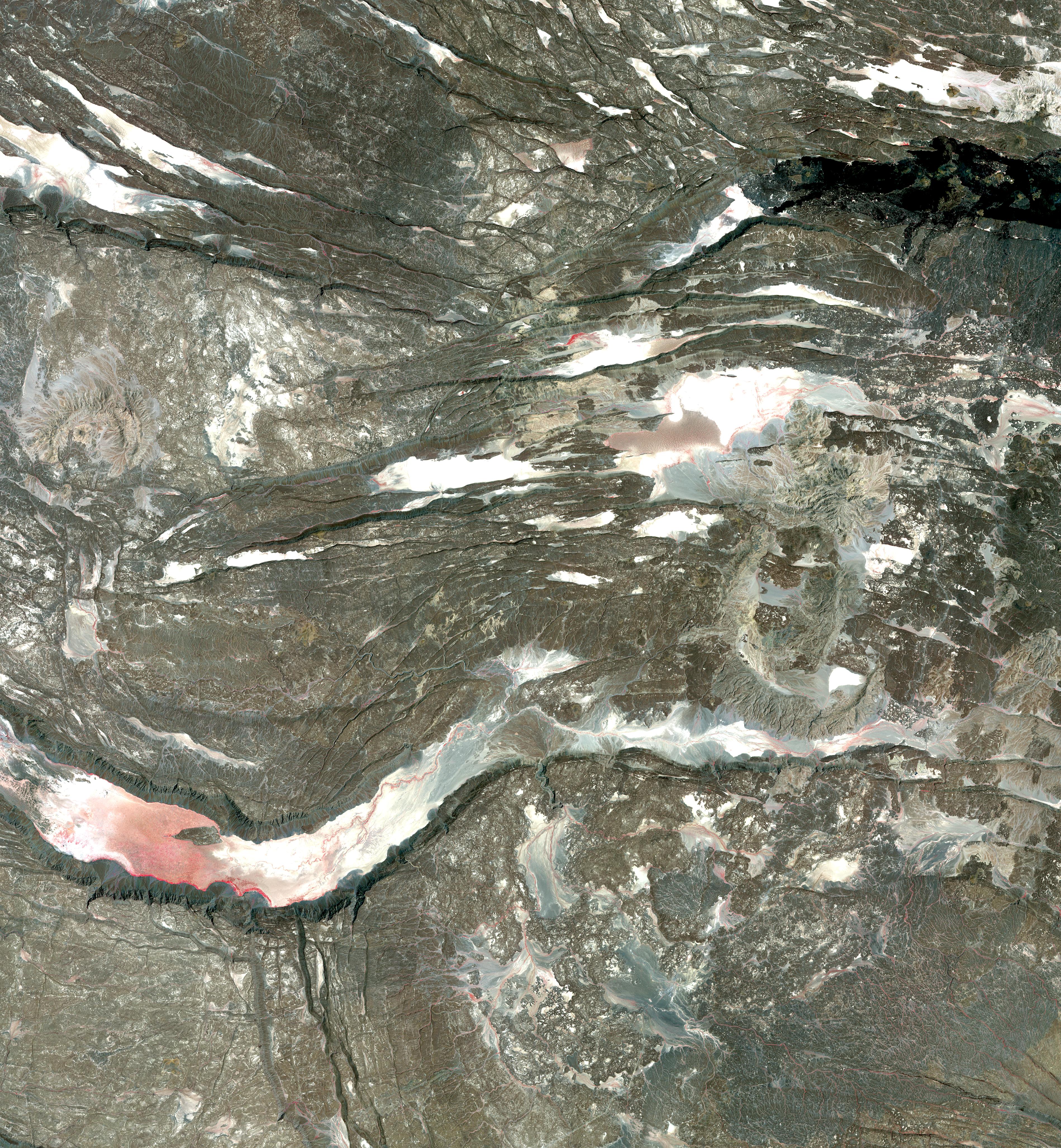
In eastern Africa, in the Afar region of Ethiopia, a
nearly barren rockscape marks the location of the meeting place of three
separate pieces of the Earth’s crust. This meeting place is known to
geologists as the Afar Triple Junction; the central meeting place for
the three pieces of Earth’s crust is around Lake Abbe, just to the south
of the area shown in this image from the Advanced Spaceborne Thermal
Emission and Reflection Radiometer (ASTER) on NASA’s Terra satellite. The three pieces of Earth’s crust are each pulling away from that central point, though not all at the same speed.
The pulling apart creates enormous stress on the rock, producing
cracks, faults, volcanoes, fumaroles (gas vents), escarpments, and hot
springs in the region along the border of Ethiopia, Eritrea, and
Djibouti. In this image, the gray-brown, ancient, basalt rock of the
region is crisscrossed by cracks both small and large, many of which are
filled with salt and sand, though in this infrared-enhanced satellite
image, the tinge of red indicates some hardy vegetation eking out a
living in the harsh terrain. The large river-like feature running
horizontally across the scene is actually a geologic feature called a
“graben,” a gulley created not by erosion of a river but by the sinking
of the ground when earth on either side pulls apart.Besides its unusual geology, the Afar region is famous for its fossils. On November 24, 1974, a team of American paleoanthropologists led by Donald Johanson discovered a fossil hominid of a young adult female only a meter tall. While the team examined the find, the Beatles song Lucy in the Sky with Diamonds played on the radio, and the team decided unanimously to call the fossil “Lucy.” Years later, she got her formal scientific designation: Australopithecus afarensis. Radiometric dating of underlying volcanic rocks placed Lucy’s age at 3.2 million years old.
A bit more re Cush being circumnavigated by an Edenic river
From: NASANews@hq.nasa.gov
Douglas Isbell
Headquarters, Washington, DC                 December 6, 1996
(Phone: 202/358-1753)
Sender: owner-press-release
Precedence: bulk
RELEASE:  96-251
SPACE RADAR UNEARTHS SECRETS OF THE ANCIENT NILE
One of the many great mysteries of the Nile river may be solved with the discovery of an ancient river channel buried under layers of sand in the Sahara Desert in Africa.
The buried river channel was revealed in images taken by the Spaceborne Imaging Radar C/X-Band Synthetic Aperture Radar (SIR-C/X-SAR) that flew twice on the Space Shuttle Endeavour in 1994. The radar images were processed at NASA's Jet Propulsion Laboratory (JPL), Pasadena, CA, and the University of Texas at Dallas (UTD).
"One of the things this discovery helps us examine is the origin of what's called the Great Bend of the Nile," said Dr. Bob Stern, a SIR-C science team member at UTD. "The Nile generally flows due north, but in the Sudan, it makes a huge, looping bend that is really remarkable because the river is flowing through the Sahara Desert, the largest, driest desert on the face of the Earth. There must be a very good reason for the river to make this great bend, otherwise we would expect it to flow straight to the Mediterranean Sea." Instead, it bends southwestwards and wanders through the Sahara for another 200 miles before resuming its northward course. "The discovery of the river channel shows us that probably sometime between 10,000 and 1,000,000 years ago, the Nile was forced to abandon its bed and take up a new course to the south. This buried channel proves that this region has been tectonically active and shows us how this activity has forced the river to change its course," Stern said. "Understanding what controls the course of the Nile is a critical part of understanding Nile history and predicting Nile behavior, which is important because the river is essential to millions of people in Egypt, Sudan, and Ethiopia."
A scientific paper on the discovery written by Stern and co-authored with UTD geologist Dr. Mohamed Gamal Abdelsalam appears in the Dec. 6 issue of Science magazine. The discovery grew out of research that the scientists have been doing on plate tectonics and the formation of a "supercontinent" more than 600 million years ago.
"Our original experiment involved studying ancient structures in Precambrian rocks that formed where two supercontinents collided hundreds of millions of years ago. In the course of our study, we became interested in how these structures influenced the course of the Nile," explained Stern.It was the tantalizing radar images of the area hidden beneath the sands of the Sahara that turned the scientists' work in a new direction.
"This discovery wouldn't have happened without SIR-C/X-SAR imagery. Our work in northeast Africa would have been limited to what we could see on the ground or could be seen in satellite photographs. The radar is much more efficient in getting information from these sand covered areas because the radar waves are able to penetrate the sand. SIR-C/X-SAR imagery has revealed a huge piece of the Earth's surface -- an area that's never been seriously explored before," Stern noted. "This is one of the most exciting discoveries from the SIR-C/X-SAR mission to date. I expect we'll continue to be surprised by fascinating results like these as the science team continues to analyze the radar data," said Dr. Diane Evans, the SIR-C project scientist at JPL. "More and more we are finding the radar data have applications to answer questions about the Earth that were not originally anticipated."SIR-C/X-SAR is a joint mission of the United States, German and Italian space agencies. JPL built and manages the SIR-C portion of the mission for NASA's Office of Mission to Planet Earth, a program to study the Earth's land, oceans, atmosphere and life as a total, integrated system.
---end---
PS Compare the DD of -4252 with Enos' rule according to Dave Fasold and Berossus and the titling below
The -4247 of the Talmudists has a resonance too.
From Fred R. Coulter’s “The Holy Bible in its Original Order A new Translation” Gen 4:25-26 “And Adam knew his wife again, and she bore a son and called his name Seth, for she said, “God has appointed me another seed inplace of Abel, whom Cain killed.” 26 And there was also a son born to Seth, and he called his name Enos. At that time men began to call upon the name of the Lord.”*
*An equally valid translation could read; “At that time men began to call themselves after the name of the Lord.” This is undoubtedly a reference to the mighty men of old who called themselves gods and incorporated the names of the Lord into their own names and titles.
posted by "Elderly R" @ 23:21
0 Comments
![]()
